
It can be quite difficult to separate Greetland from West Vale and I have yet to see any actual borders. Therefore, some of these photos are overlapped onto each page.
Many thanks to Steaven Heppener and Graham Jagger for permission to display their photos.

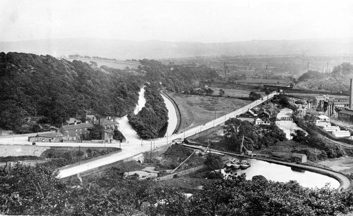
In the picture above, we have come from Salterhebble (left centre).
The main road continues past the top side of the 'Calder and Hebble' pub and runs parallel with the canal on towards Elland (top of picture).
Our tour takes the road which we see running along the bottom side of the pub and continues towards West Vale and Greetland (top right).
The other, wide looking road, which enters from bottom left, comes from Copley.
We can also see the canal basin (bottom right) with the river above it.


 |
 |


Mackintoshes Tennis courts left and Cricket ground bottom with Heath rugby ground right. Charles Lambert & Co at North Dean Dyeworks became a West Vale garden centre.


Greetland and North Dean Railway Station, opposite the cricket club


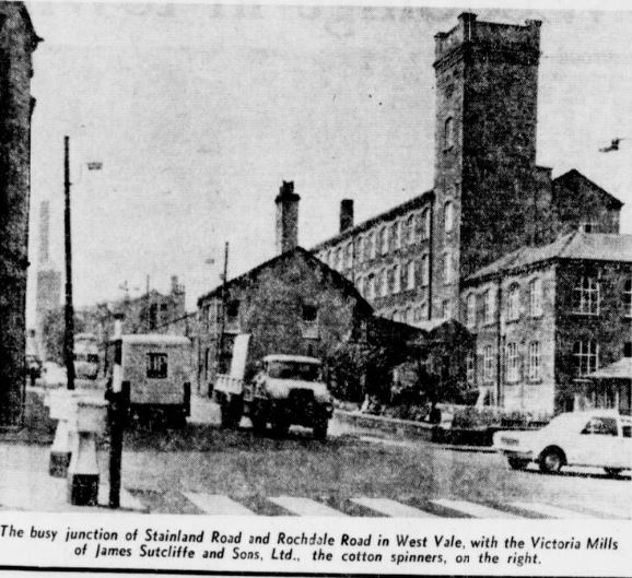
Stainland Road looking towards Salterhebble with the site of Greetland and North Dean Railway Station to the left.

John Horsfall & Sons Mill can be seen on the left

Prospect Mill is just behind Horsfalls Mill


West Vale -first crossroads
We have reached this point from left of picture. Firstly we can view Calder Street, straight forward. The road behind the gent takes us towards Elland. The road to the right of picture continues through West Vale to a second crossroads and on towards Holywell Green and Stainland. There is a road behind us that goes towards Greetland and on to Barkisland and Ripponden.

1st left at the crossroads, Calder Street. West Vale Academy and St.John's Church


Runaway lorry coming from Elland

This is the road from West Vale towards Elland. Long Wall back towards West Vale and Salterhebble (top right).

Again we look back towards West Vale. The top road is bringing us towards Hullen Edge while the bottom road brings us towards Elland Bridge. The steps take us to Hullen Edge Park.


Looking back towards West Vale
Continue here to Historic Elland

We have returned to West Vale and John Horsfall and Sons

Back at the crossroads, and now we shall take the road towards Ripponden.


Brig Royd Mills can be seen on the right. The road towards Barkisland and Ripponden is on the right
 |
 |


Clay House Mill
 |
 |

We have returned to West Vale - First Crossroads (in the distance right)
We are now at West Vale - Second crossroads
Left of picture is Saddleworth Road towards Barkisland.
Right takes us on a route to Elland and behind us would travel towards Holywell Green.


Saddleworth Road towards Elland

Shears Inn


 |
 |

Saddleworth Road

Saddleworth Road looking towards Barkisland.

Greetland Cricket Club to the right of picture.
Exterior shot of J. Horsfall & Sons Ltd, Ingwood Mills, Stainland, West Yorkshire.


 |
 |


Stainland Road


Back to West Vale again. There are several side streets here with lots of terraced housing.
Green Lane

Green Lane is on the top side of one of these streets


Stainland Road cont.


We are now heading towards Holywell Green, where this tram has come from.
 |
 |


If you have any photos or articles you would like to add, please send to info@halifaxpeople.com
Have A Great Story About This Topic?
Do you have a great story about this? Share it!
If you have enjoyed your visit to this website, please spread the word by clicking the 'like' and 'share' buttons below. Thank you


